Friday, October 19, 2012

Day 10-12 The road to Nelson (Ah the serenity)


We left Robe reasonable early and headed back to Wellington then down through Tailem Bend, Meningie and Mt Gambier then onto Nelson and Prichard’s. This was a bugger of a trip (again) as we ran into wind, rain and hail again. We kept moving so no photos but as we approached Nelson the weather improved and by the time we reached Prichard’s it was warm and clear, but late. 
Camp Nelson


One of our friends

Prichard's
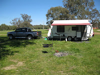
 We set up camp lit the fire and relaxed. Both our vans have 12v so we had no probs with lights etc and the fire and gas kept the hot water up. As I mentioned earlier this was a bit of a trial to see how we could cope in the free camp environment. Gaz and I are pretty used to it as we camp here regularly and I’m happy to report that after 2 nights it was a resounding success so look out. The shower proved to be a success and in fact better than some of the van parks we have stayed in. Prichard’s has a plethora of wild like which roam in and out of the camp constantly. Kookaburra’s, kangaroos, blue and jenny wrens, finches etc etc. These provided endless enjoyment and interest to us not only because they seem untroubled by us but there antics around us. The only down side I can see is there are probably people who will take advantage of this to do them harm. Our 2 nights here have been relaxing and rewarding and as we pack to head home I will be sad to wake up without them around. Gaz and I always enjoy our time here and I am pretty sure Di and Shaz have as well. Ah well back to reality for a while. Di and I will be home for a day then off to Perth which is a combination of work and holiday for me and hopefully R&R for Di. It has been another great trip for the Tagalong Tours group – not long enough as per normal – but planning is well underway for our next sojourn.  D&D
Another friend


Day 9 – Last day in Robe


Today was just a lazy day really, tomorrow we head for Prichard’s landing in the Lower Glenelg  national park for a bit of “free” camping. No power, no showers etc so it will be interesting. It’s a bit of a test for the girls to see whether we can set up a “suitable” setup to allow a bit more flexibility in our travels. 
The Obelisk

The "door"

One of the "oldies" of Robe

The building Joan Sutherland
spent time in


We went walking the streets of Robe and there are a lot of old sandstone buildings which are just magnificent. I love these old buildings and most are being looked after. We came across one which had been the home of Joan Sutherland for some time. Many of the buildings have historic plaques on them giving a brief glimpse of the history of each. We also visited the Obelisk which sits on a spit of land by the sea. It was built by a local builder to guide ships into the harbour. It had a few problems in its early history; first being painted white was difficult for the ships to distinguish from the sand. It was then painted red and was difficult to distinguish from the land, in the end it was painted red and white stripes which seemed to solve the problem. The structure is now in danger of collapsing into the sea and there is very little which can be done to protect it from its fate. There was our (by now) obligatory visit to Mahalia’s for coffee and sadly it is our last (but we have some take away beans). Gaz and I did a bit of fishing from the sea wall and managed a couple of tiddlers. We were visited for a while by a very inquisitive young seal who provide us with some light relief for a while. We, obviously, were not as interesting cause he sauntered of into the marina with barely a look back!

Friday, October 12, 2012

Day 8 – Beachport, sand, scenic drives and bogged to the axles

Life is looking up the weather today isn’t too bad at least its not raining and the wind is dying down. We decided a trip to Beachport was in order via Little Dip conservation park and 4 WD track that followed the coast. All started pretty good and it would be fair to say between Gary and I our 4WD experience was limited and we have no desire to really be hard core, just to get enough experience to allow us to stay safe.
Track into Little Dip
 The trip along the conservation reserve track was spectacular and tested us with rocks, sand, steep assents and descents and very narrow winding tracks. The scenery and places we stopped were fantastic and our confidence grew a little. We had gone maybe 25 kms when the track actually transversed the beach for quite a distance. Now two things we, in hind sight, would have been good to know, 1) sections of the track had been closed due to washaways and 2) the wild weather had put a LOT of soft drift sand up on the beach. 200 mtrs in Gary’s bogged to the bum in soft sand. With a lot of digging and lower tyre pressures (15psi) we got the Prado out but any attempts to go further were deemed not to be in our best interest.
Gaz bogged


Me bogged
 The girls by the way were having a ball, thought it was a great joke. Now we had another small problem we had to turn around. Gaz managed to get around ok on the edge of the soft sand I, however, made a tactical error (maybe 2) I executed the same turn and pulled up behind Gaz – on soft sand and promptly got bogged. A bit more digging and lower tyre pressure and we were on our way backtracking to Robe. From Robe we went out on the bitumen to Beachport then took the dirt around the back of Little Dip conservation area to Beachport. This again afforded us some great sites and was pretty easy. As we came back onto the black top we came across the Woakwine Cutting which is an incredible feat and was completed by 2 men to drain a swamp land for farming. The project started in May 1957 and took 3 yrs to complete.


Some of the sites along the coast
The length of the cutting is about a km and 28.34 mtrs deep at its deepest point. The cutting is 36 mtrs wide at the top and 3 mtrs wide at the bottom. They took 276,000 cubic mts of material out and used a new D7 dozer.
More sites along the coast

Woakline Cutting

Beachport
 From there its was on to Beachport which is a nice little town with a population of about 400. There is a marker at the entrance to the town commemorating the death of the first 2 Australians during World War 2. They died on the beach at Beachport trying to destroy a German mine which had washed up on the shore. A trip around the rest of the town and then back to Robe for dinner.   By the way I think Dave has omitted some fairly important information.  In Robe there is a coffee shop of the beaten track called Mahalia’s where they import beans and blend them we have been in for coffee 2 days in a row and will go back for the last time tomorrow!!


Thursday, October 11, 2012

Day 6 & 7 - Rain, Hail Wind and 4WD


As you may have guessed there was no post yesterday. We left Cape Jervis to head for Robe and there was always a threat the weather was going to be bad. There are no photos of the trip down, well because we couldn’t really get out of the cars and even if we could you couldn’t see much.
Cube House at Port Elliot

 We battled gale force winds, hail stones, driving rain and spray from trucks. I must say even confronted by all that the BT 50 went well. We arrived at Robe about 4ish and in the 10 minutes between more showers, winds and hail we set up then hibernated for the night. The weather continued over night but we were snug and dry. The caravan park we are staying at sites between two lakes and the buildings are classified by the national trust. The office and reception building is the old stables and  is complete with the original pug and post flooring.
Old Stable at Robe C'van park


 Today the weather cleared a little but was still threatening but we ventured out. First stop was Robe and the “I” centre, a bit of a wander then a planning coffee. The “I” centre had a museum attached and chronicled the early history of Robe, which apparently was the dropping off point for many of the Chinese destined for the gold fields in Victoria. There were a couple of stories, one in which 260 odd Chinese left Robe for Bendigo only 16 made it. At one point there were approx 17000 Chinese in Robe. We decide to chance the weather and went back to make lunch and head for Cape Jaffa. We had a bit of a poke around and it’s a bit interesting. It looks a bit like their trying to create some sort of up market living. They have created a series of canals which have subdivided land fronting them so each property has a jetty etc. Not too many houses at the moment and I’m not sure how it will go Robe is sort of half way between nowhere and somewhere else. We managed to get the 4by’s on the beach for a short trip which gave Gaz a bit of a taste for beach driving. 

Restored Cape Jaffa Lighthouse
The light house has been removed and has been restored and sits in Kingston SE. Lunch was had amongst the dunes and was pleasant except for the wind. We packed up and headed for Kingston SE. There were 2 priorities 1) to see the restored lighthouse and 2) to visit the scrapbooking shop. We managed both with most of the time allocated to the scrapbooking shop – they had a sale on. From there we headed north again to a place called the granites which are a few gigantic granite rocks somehow thrown into the sea. A receding tide, however, had not receded enough to see them in their full finery. Ah well another beach drive made it worth while. On leaving Granite rocks we found a dirt road heading north which ended up going between the beach and the lower reaches of the Coorong. It went for about 40 kms and was interesting. The water in the swamp parts going from a pink colour through grey to brown and the vegetation changed all the time. It was pleasant and worthwhile drive and gave Gaz the opportunity to get his car a bit dirtier. Di keeps saying boys and their toys. We came back on the highway about 60kms north of Kingston SE so the drive back was quite uneventfully or exciting, except for the wind and the rain which have reappeared.

Road to the beach

On the beach

Lower reaches of the Coorong North of Granite rock

Tuesday, October 9, 2012

Day 5 Tourist route and 4WD

Hindmarsh Terraces
Hindmarsh Terraces

Over breakfast we decide today we would do the tourist route, which went up to Myponga (there it is again) then we deviated. Gaz and Shaz hadn’t been up to Myponga so they were able to see a bit of new scenery. We headed south east from Myponga with our first destination Hindmarsh Terraces water fall. It was a couple of kms off the main bitumen along a dirt road then a short walk. It was well worth the effort, although not a lot of water over the falls, for a nice and peaceful start to the day. The falls cascade down over a series of ledges so hence the “tiers”. Back onto the bitumen for a few Kms then we turned to head for Glacier Rock, about a 10 km drive. Glacier Rock is a bit of a surprise  mainly because there is this most pleasant café in the middle on nowhere – bugger all else. We didn’t venture in but were tempted a short walk from the carpark was glacier rock which apparently was dumped there 450 million years ago by a glacier from Kangaroo Island. It is in the middle of a small stream but with much of the rock face exposed.  
Glacier Rock
Read the sign on the middle door
After Glacier Rock we decided lunch might be in order and with pre prepared picnic in hand we stopped at a place called Inman Valley. Now it is a quaint little town but not much there apart from a nice place to picnic. It does, however, seem a bit quirky as the picture shows (look closely at the toilet block) brings a whole new meaning to sending brown parcels.  Lunch out of the way we headed of to Ingalalla Falls and conservation area. This would have been not a bad place for lunch either. A short walk to the falls then back to the car. These falls, although very nice were not as nice as the Terraces. On the road again we headed for a place called boat harbour. There was a fair bit of dirt road which was reasonable until we reached the unmanned ranger point. There was a 4WD track to a place called boat harbour. Now we had a 4WD and a permit so this was made for us. We had gone about 500 mtrs  when we ran into the rangers clearing the track. I would appear as though the track was just opened after the winter closure (not 15 minutes earlier). They advised we could continue but didn’t know the condition of the track. Gary has a new Prado which has every known button in 4WD technology and we used most. Whilst the road would be considered by some hardened 4WD  as a walk in the park to us uninitiated it was a challenge. In the end we got to Boat Harbour, loved the drive and were given a glimpse of some fantastic scenery. Gaz is pretty thrilled as he got to give the new wheels a bit of a test. After that the trip home was mundane really. Ahh well tomorrow we move on to Robe -  maybe we can get on the beach!!!


Boat Harbour

Grass Tree - Boat Harbour

Day 4 Myponga – Dejavue

Morning Delight

Today we rose to another nice day and contemplated the multitude of options open to the wind swept and interesting people that we are (you all may stop sniggering now). There were two sort of loose options we had and in the end we elected to head up to Hahndorf. Now this necessitated a return to yesterday’s travels in that to get to Hahndorf we had to go back through Normanville and Myponga. Just north of Myponga we turned on to B34 which took us up through the back blocks to Hahndorf. It was well after morning tea time so coffee and cake seemed to be in order at one of the many eateries, suffice to say it was very nice. I’m sure the photo is self explanatory. Hahndorf hasn't changed much since we were last here so there is not much to report. 
Main St of Hahndorf


We had a bit of a walk around and let a few hard earned $$ change hands and spent a few hours in the town. An observation though the town seems to be giving up some of the Germanic heritage for which it is noted. At the moment it is very subtle but its there. Chinese, Indian and an Indian/Asian combination that came 2nd in some state competition.  Some of the traditional German influence is also being replaced by a more cosmopolitan retail sector.  It was then on home to wait for Gaz & Shaz to arrive with a slight detour to Rapid Bay. This is very picturesque spot, except for the remnants of the old quarry and is a good fishing spot for a number of species including squid. It is also the home of the leafy sea dragon and is popular with divers and fisho’s alike.  We met a couple of fellow travellers from NSW and had an early happy hour while waiting for Gaz to arrive. The place is pretty full to night with a variety of travellers, some on motor bikes, small vans, big vans and even an old guy from Perth living out of his Mitsubishi  Colt. Which is a bit of a worry for us after he asked s to check and make sure he was still breathing in the morning!!  

Rapid Bay Jetty
Hole in the wall - Rapid Bay


Sunday, October 7, 2012

Day 3 Cape Jervis – Day tripping

Sunset over Cape Jervis

Today we thought a bit of a day trip was in order and after consultation with the tourist map, the gods and a few locals we discovered the font of all knowledge in relation to tourist stuff (the “I” centre) was at a place called Yankalilla. So we headed off about 10ish. The road is the main black top from Cape Jervis to Adelaide. We had travelled some of the road on the way in and the scenery was pretty good. There are a heap of places for ohhh and ahhh moments. The road is pretty windy and quite narrow in places and I was a bit surprised when we past (going in the other direction) a big F250 with tri axle caravan in tow!!!. Just before Normanville there is a look out with information about HMAS Hobart which was scuttled to make an artificial reef. 

Road into HMAS Hobart Lookout

Something different at the Allure Winery

Karen Hannatt's Studio


The anchor has been mounted at the look out pointing to the location of the wreck. From there it was on to Normanville and Yankalilla for morning tea. Our plan after morning tea was to take a short drive to a winery so a short drive north then on to a dirt road for a couple of km to the “Allure” winery. What a surprise packet a place with a great outlook and not bad wine in the middle of this valley. From there we followed a few dirt roads and ended up back on the coast and heading back to Normanville and the big “I”. Di had seen ads for an artists studio in Yankalilla run by Karen Hannatt so we decided a bit of a squizz was in order. It’s a small but interesting gallery (a work still in progress). It was made of mud with the main part round. Di found plenty to interest her in here and Karen proved very friendly and interesting.  Over lunch we contemplated our next move. We had heard of a market at a town called Myponga so we headed to investigate. Unfortunately it was disappointing. We did however come back with some info to help with tomorrows run. On the way home we took a detour to place called Second Valley to check out a possible fishing spot and were pleasantly surprised. It was very picturesque and looked quite promising and there were people out in kayaks (thumbs up Gaz). Now here’s a question where do they come up with some of these names for some of these towns, surely there was a name available better than Myponga – seems more like the name of a disease or a bad smell.
Second Valley Jetty


Saturday, October 6, 2012

Day 2 Wellington to Cape Jervis

Shearers quarters at the station
More of the station

Well I won’t say it was a fantastic sleep but it was better than some we have had. Wellington was a pretty quiet place and we enjoyed a nice meal at the pub looking out over the Murray. We decided on an early night I was feeling a tad weary after the drive. Bugger me if at some stupid hour of the early morning we didn’t get a thunder storm. Just one clap of thunder which I wouldn’t be surprised if it had its epicentre under our van. Shook the van, gave me a jolt and frighten the bejezzus  out of Di.  Then nothing - talk about anticlimax. After brekky as we prepared to leave we struck up a conversation with the couple next to us. They were elderly I would say late 70’s early 80’s and they had been on the road for 6 months and on their way home. Seems the thunder did their constitution no good either. We meandered our way west from Wellington, through Victor Harbour to Cape Jervis to our accommodation for the next few days at least. We are staying at Cape Jervis Station which is a working sheep station with a few cabins, powered and non powered sites. Is very casual and quiet and so far I like it. Very different to the usual van parks. The weather has been off and on between warm and sunny to bloody freezing, rain and wind strong enough to knock you over.  We didn’t do much today other than a bit of a look around Cape Jervis.  What a popular place to stay this has been it is full quota tonight at least for vans not sure about the cabins but it is turning very cold think we will have a cold night tonight!!
Cape Jervis Lighthouse


Some of the locals

More locals

Ferry station

Friday, October 5, 2012

Day 1 Home to Wellington (SA) – Let the games begin!!!


Well we are off again woke at sparrow fart again – our sleeping habits are ridiculous at the moment but to be honest it was great to be on the road again and heading anywhere but Melbourne. We left the oldies to look after each -we will see if they survive each others company.  We headed out through St Arnaud to Dimboola then west to Tailem Bend finishing at a little place on the Murray called Wellington. Today was a driving day really but we stopped a few times.
Park at Border town


 Lunch was at Bordertown and the local bakery was nice and a bit unique. It is actually a building built over a couple of old buildings. There were some pretty expansive garden areas and ponds all very pleasant really. We got into Wellington around 3ish after a trip across on the ferry from east to west on the Murray.  Must say I’m pretty happy with the car and van averaging about 14 ltrs per 100kms fully loaded cruising at about 100 kph. Lots of traffic from about Border town through in both directions but all pretty well behaved. We have Dougal 2012 (the daffodil bear) with us this year again so keep your eye out for him in the photos.
Dougal

Old port building Wellington

Wellington Ferry


Sunday, September 23, 2012

Tripping Time again

Ahh the time is nigh our next trip is close at hand so this weekend we had a bit of a teaser before we head off. Di and I along with Fay and Wayne went to Aysons Reserve for a spot of free camping. Aysons reserve for those that don't know is the old Elmore Field Days site on the banks of the Campaspe River.
Our overnight trip served a couple of purposes 1) to give the van and the new tow tug a bit of a shake down and 2) to have a bit of a go at free camping. Both were successful but the bonus was we got to do a bit of fishing.

Fair to say we lost a bit of gear, some more than others (eh Wayne). Between us all I think we managed 4 carp and a juvenile yellow belly. Yellow belly returned to its home carp become fertiliser. Wendy dropped in on Sunday so the girls went into Elmore to the tea house whilst Wayne and I chilled. Di didn't mind the free camping and is talking about a few mods to make free camping life a bit more enjoyable for us. So I guess you could say success all round. Interesting mix of accommodation (vans, motorhomes, converted buses etc) and people of course (and pets). Some had been here for months apparently. I'm not sure this helps in promoting free camping for the travelling wilbury's (not ready for grey nomads yet). Anyway if you want a good weekend camp spot this is the one. Think we will be back. Thanks again Fay and Wayne for the great company.